Paragliding Takeoffs in Gran Canaria: Everything You Need to Know
In Gran Canaria, there are more than 20 takeoff points for paragliding. If you have an appointment with one of our pilots, make sure to know the name of the takeoff and head to the correct location.
How to avoid confusion?
Some takeoff points are very close to each other. If you ask the locals, you might end up in the wrong place. That’s why it’s key to be clear about the pilot’s name and the exact location of the takeoff. Remember that the pilots are usually in the air and it can be difficult for them to help you if you get lost.
Remember that if you’re looking to give something truly original this Christmas, we have a “Crazy Adventure” pack that makes the perfect gift—an unforgettable experience. Check out our offer at this link.
The most popular takeoffs in Gran Canaria
In Gran Canaria, the three most famous takeoffs are:
- Los Giles (two different takeoffs)
Giles Norte
Giles (Ladera Alta) - Las Coloradas
If you plan to go to Los Giles, pay special attention, as there are two takeoffs in the same area. This is even more important if you’re traveling by public transport, to avoid arriving at the wrong place.
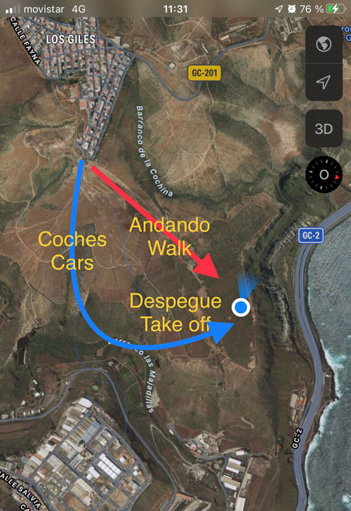
Giles Norte
Driving route from Las Arenas:
- Going up from Las Palmas, take the first exit towards Costa Ayala.
- Go up the mountain towards Los Giles.
- Pass the town of Ladera Alta, always heading towards Los Giles.
- Before entering the town of Giles, the first street (you’ll see a sign for Rosy hardware store) follow this street to the end, it’s called Fray Escoba.
- At the end of the street, there is a dirt track that leads to the takeoff.
- The takeoff is the green carpet you can see at the edge of the cliff.
Note: Depending on the time of year, access to the dirt track may be in acceptable condition or not. It’s up to you whether to drive down; it’s a 10-minute walk. If it’s a hot day, bring water with you.
Bus route from Las Arenas:
Click “More options” on the map to see schedules.
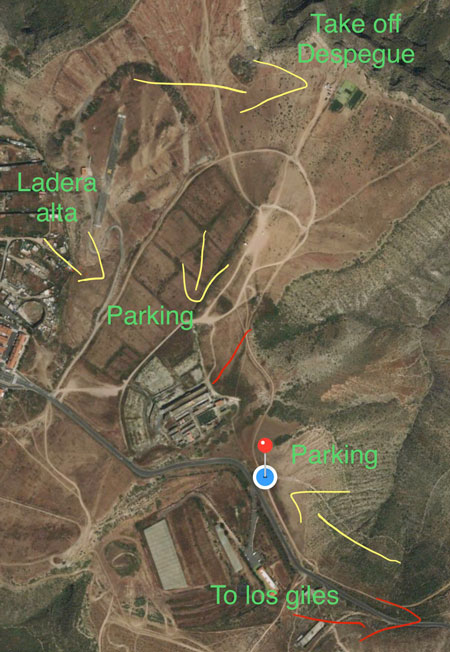
Giles (Ladera Alta Town)
Driving route from Las Arenas:
- Going up from Las Palmas, take the first exit towards Costa Ayala.
- Go up the mountain towards Los Giles.
- Pass the town of Ladera Alta, always heading towards Los Giles.
- Right after exiting the town, there’s a ruined house (an old dairy farm) on the left-hand side on top of the hill. Go up the dirt road that leads to the farm and follow it for a few meters to the left until you take a small turn left that will lead you to the parking area.
- Walk straight along the path you were on until you see the green carpet at the edge of the cliff.
It’s very important to ensure you don’t block any vehicle access where you park.
Another option (marked on the map) is to park in front of the senior center and follow these instructions from that point.
-
Follow the dirt road that has a chain and pass the chain on foot.
-
Stay on the main dirt track until you reach the takeoff carpet (you won’t see it until you’re 50 meters from it).
Bus route from Las Arenas:
Click “More options” on the map to see schedules.
Las Coloradas
To reach Las Coloradas, follow these directions:
- Take the GC-1 highway until the C/ Perez Muñoz exit (U-turn).
- Follow Perez Muñoz to the end and then take Coronel Rocha Street.
- Turn right to connect with the road to Las Coloradas.
- Reach Las Coloradas and once there, go to the end of the town on its left side, leaving the football field on your left.
For public transport, click “More options” on the following map or download the PDF schedule for Line 41 Municipal Buses.
Thanks for trusting Aventura en Canarias